Archives

Share Archives on Facebook Share Archives on Twitter Share Archives on Linkedin Email Archives link
Oak Bay Archives search room with virtual users

The Archives are open to visitors & researchers in person by appointment in advance during staffed hours, normally on Tuesdays and Fridays 9.30-4. Drop-in hours: Tuesdays 10-1.

The usual Archives entrance is on the ground floor on the east side of the building (nearest Fairway Market). This entrance is step-free. You can also request Archives access via the front desk upstairs in Municipal Hall - ask the staff member at reception to phone the Archives office, and the Archivist will meet you in the foyer. Please note that indoor access from main reception involves a full flight of stairs.

Enquiries

The Archives are open to visitors & researchers in person by appointment in advance during staffed hours, normally on Tuesdays and Fridays 9.30-4. Drop-in hours: Tuesdays 10-1.

The usual Archives entrance is on the ground floor on the east side of the building (nearest Fairway Market). This entrance is step-free. You can also request Archives access via the front desk upstairs in Municipal Hall - ask the staff member at reception to phone the Archives office, and the Archivist will meet you in the foyer. Please note that indoor access from main reception involves a full flight of stairs.

Enquiries are also welcome any time by email, phone and post:

Email: archives@oakbay.ca
Tel: 250-598-3290 (please include an email address in your message if possible)
Oak Bay Archives
2167 Oak Bay Avenue
Victoria, British Columbia V8R 1G2

On this blog: posts about local history and Oak Bay Archives holdings from the municipal archivist and archives volunteers.

Links:

Blog Index

Oak Bay Archives historic photographs

More about Oak Bay archives

  • Historic Weather Events - Municipal Hall foyer display, December 2021

    Share Historic Weather Events - Municipal Hall foyer display, December 2021 on Facebook Share Historic Weather Events - Municipal Hall foyer display, December 2021 on Twitter Share Historic Weather Events - Municipal Hall foyer display, December 2021 on Linkedin Email Historic Weather Events - Municipal Hall foyer display, December 2021 link
    supporting image


    In a year of unusual meteorological events from heat domes to atmospheric rivers, it seems appropriate to close the year's MH foyer displays with some historic photos to put them in context.

    1) Oak Bay Avenue at Hampshire, looking west, during the December 1996 snowstorm. Photographer: Oak Bay Fire Dept, 29 December 1996. OBA PHOT: 2012-001-146 View online

    Anyone who was living in Victoria in the winter of 1996-97 will remember that Big Snow: “The blizzard of 1996 set records by dropping 124 centimetres of snow in Victoria between Dec. 22 and Dec. 29. The worst blast of winter weather to reach Vancouver Island since 1916 brought multi-million dollar damages to the region” Keri Coles, Victoria News Dec. 27, 2018

    Did you know that record had stood for 80 years? Fortunately for us, the Big Snow of 1916 was unusual enough for its time for contemporary photographers to record it.

    "Because of the massive amount of snow, the army deployed 150 soldiers [from Willows Camp in Oak Bay] to the city to help – soldiers from the 88th Battalion (Victoria Fusiliers), the 67th Battalion (Western Scots) and 103rd Overseas Battalion. In some areas, the snowdrifts piled up to 70 inches in depth." - Michaela Ludwig, British Columbia Magazine, November 2, 2016 For a contemporary account, see the Daily Colonist newspaper, 4 February 1916, p.4

    On the same day, the Daily Colonist noted :“The municipality of Oak Bay made considerable progress yesterday towards opening up the main thoroughfares to traffic. A gang of men worked all day with teams and a snow plough and by tomorrow night it is expected that it will be possible for merchants to reach all parts of the municipality with their deliveries.” - Daily Colonist newspaper, 4 February 1916, p.5.

    2) Oak Bay Public Works crew, aided by the municipal horse team, clear the tracks at the Oak Bay Street Car terminus, near the corner of Newport and Windsor Road. Public Works Superintendent Samuel Gunter on the right. Oak Bay Hotel in background, far right. February 1916. OBA PHOT: 1994-001-022 View online

    The one mention of the Big Snow in Oak Bay Council minutes, apart from the lack of meetings in the first part of February, is:

    “The Reeve stated that he would like to have a letter sent to the B.C. Electric [Railway] Company thanking them for hauling out the coal free of charge during the recent severe weather… The Reeve also stated that he had sent a letter to the Admiralty thanking them for supplying the Municipality with 2000 sacks, as without such it would have been impossible to have obtained the coal.”

    - Oak Bay Municipal Records. Council Minutes 1916, p.11.

    3) Clearing Government at Johnson Street during the Great Snow of 1916. At left is 1401 Government St, designed by Leonard Buttress Trimen and built 1881 for EG Prior Hardware, now a listed heritage building. Copy loan from private collection – original not held at Oak Bay Archives. Patrick Family Album, 1916. OBA PHOT: 2015-000-014 View online

    4) Horse drawn snow plow clearing Government Street at Fisgard after the Great Snow of 1916. Copy loan from private collection – original not held at Oak Bay Archives. Patrick Family Album, 1916. OBA PHOT: 2015-000-020 View online

    5) The #2 Oak Bay Streetcar makes its way along Douglas Street through the snow. Copy loan from private collection – original not held at Oak Bay Archives. Patrick Family Album, 1916. OBA PHOT 2015-000-015 View online

    It's not so surprising that an exceptional weather event like the 1916 snowfall might have prompted photographers to get outside and record it (did they use snowshoes? skis?) whatever the equipment and effort required, but outdoor and informal photographs proliferated with the advent of the highly portable, simple to use Kodak Brownie box camera in 1900. Here are some more photos of historic Oak Bay weather, datable from album context to pre-1920.

    6) Downtown Victoria after snow fall, near James Bay. Photographer: Frank Burrell, ca.1900. OBA PHOT: 2010-010-285 View online

    7) Homes in the snow: looking west from Gonzales Hill, over Foul Bay Beach. Unwin-Hinkins album, ca. 1916. OBA PHOT: 2006-006-012 View online

    8) House in Oak Bay ?near Gonzales Hill after snowfall. Unwin-Hinkins family album, ND ca. 1916. OBA PHOT: 2006-006-013 View online

    9) Snowy tree-lined road, probably in south Oak Bay. Unwin-Hinkins family album, ND ca. 1915-16. OBA PHOT: 2006-006-015 View online

    Personal photo albums include images of windy or stormy weather as well as picturesque snowy scenes. How different would a photo look taken from these locations today?

    10) Looking toward Trial Islands from Shoal (McNeill) Bay on a stormy day. Unwin-Hinkins family album, ca.1915. OBA PHOT 2006-006-009 View online

    11) Stormy weather at Shoal (McNeill) Bay, looking east toward Anderson Hill. Unwin-Hinkins family album, ca.1915. OBA PHOT: 2006-006-010 View online

    12) Storm over Oak Bay, taken by Frank Burrell ca. 1910. OBA PHOTO 2010-010-197. View online

    All photos displayed are modern prints from digital images. Most are enlarged, cropped and manipulated for colour and contrast.


    Interested? Read contemporary accounts of the Big Snow of February 1916 and its aftermath in the Victoria Daily Colonist and Victoria Daily Times newspapers

    More digital images of the Big Snow of 1916 (and other weather events) are available on the websites of Esquimalt, Saanich and City of Victoria Archives, and the BC Archives

    Do you have family stories, photographs or other records of historically bad or beautiful weather in Oak Bay? Please get in touch!


    Website: https://www.oakbay.ca/archives

    Photo Search: https://www.oakbay.ca/our-community/archives/photographs-view

    Blog posts: https://connect.oakbay.ca/archives

    Email: archives@oakbay.ca

    Phone: 250-598-3290


    - Post by Anna Sander, 9 December 2021.


  • Willows Camp in WW1 - Municipal Hall foyer display, November 2021

    Share Willows Camp in WW1 - Municipal Hall foyer display, November 2021 on Facebook Share Willows Camp in WW1 - Municipal Hall foyer display, November 2021 on Twitter Share Willows Camp in WW1 - Municipal Hall foyer display, November 2021 on Linkedin Email Willows Camp in WW1 - Municipal Hall foyer display, November 2021 link


    Willows Camp in WW1 - Remembrance Day display in Oak Bay Municipal Hall foyer, November 2021

    Archives display cabinet in Oak Bay Municipal Hall foyer Willows Camp was established in the Willows Fairgrounds in 1914 as a training camp for BC soldiers joining the Canadian Expeditionary Force, prior to embarkation for Europe and deployment to the Western Front.

    The Fairgrounds, including the Exhibition Building, stables, and the race track previously called Willows Driving Park, were located in the area developed after WW2 as the Carnarvon subdivision, below Lansdowne slope. The Fairgrounds borders – defined by a high wooden fence – ran along Henderson on the west, the north side of Neil on the northern boundary, a line extending through what's now Dryfe St to the east, and a line extending eastwards from the end of Haultain on the south side.

    1925 Fire Insurance map showing the Exhibition Grounds and surrounding streets. Compare with 2021 Google Maps, with former fairgrounds site superimposed in semitransparent yellow, approximate track site in blue.

    Display cabinet

    Display contents:

    1. Oak Bay Rolls of Honour, 1914-18 and 1939-45 View for WW1 View for WW2

    2. Cavalry unit entering Willows Camp via Fair Street gate. WW1, no date. Copy loan from a photo postcard?. Original postcard not found at Oak Bay Archives, digital image not available.

    3. Small group of Canadian Army soldiers in uniform, in front of a large field of white bell tents at Willows Camp, and a man in civilian clothes among the tents. The high wooden fence around the fairgrounds can be seen behind the tents. The then brand new Young Building set back from the corner of Lansdowne and Foul Bay (built 1913-15), which was first Victoria Normal School (teacher training), then Victoria College (later UVic) and now houses Camosun College, can be seen in the background, on the hill above the Lansdowne slope. 1915. OBA Photo Number: 2005-020-001. Original photo postcard held at Oak Bay Archives. View

    4. Troops Tug-o-War at Willows Camp ca. 1915. OBA Photo Number: 2005-020-003. Original photo postcard in Oak Bay Archives. View

    5. Postcard print of military training exercises with horses at Willows Camp, ca.1915. Photographer: Frank Burrell. OBA Photo Number: 2010-010-166. Original photo postcard held at Oak Bay Archives. View

    6. WWI officers at Willows Camp – right, ?Western Scots or 50th Gordon Highlanders, ca. 1915. Photographer: Frank Burrell. OBA Photo Number: 2010-010-183. Original print held at Oak Bay Archives. View

    7. Unidentified soldier on horseback at WWI Willows Camp, ca.1915. Photographer: Frank Burrell. OBA Photo Number: 2010-010-188. Original print held at Oak Bay Archives. View

    8. Quartermasters of the 67th Battalion, Western Scots Regiment, at Willows Camp, ca. 1916. Photographer: Patrick family. OBA image number: 2015-000-012. Copy loan from private collection. Original print not held at Oak Bay Archives. Digital image not available.

    9. Kilted Canadian troops drill in front of the Exhibition Building on the Willows Fairground – Willows Camp during WW1. Copy of a colourized photo postcard, no date [1914-1918]. No OBA ref. Original postcard not found at Oak Bay Archives. Digital image not available.

    10. The 2nd Battalion, Canadian Mounted Rifles, strike tents at Willows Camp, preparing to embark for Europe, 1915. Source: Okanagan Military Museum, Kelowna, via digitalmuseums.ca Not held at Oak Bay Archives. View

    11. Quartermasters of the 67th Battalion, Western Scots Regiment, marching near Vancouver Street, en route from Willows Camp to Victoria Harbour for departure to the European Front, ca. 1916. Photographer: Patrick family. OBA image number: 2015-000-011. Copy loan from private collection. Original print not held at Oak Bay Archives. View

    12. World War I troops marching from Willows Camp in the Willows Fairgrounds along Willows Road, now Eastdowne, toward Cadboro Bay Road ca 1915. Note the Willows Park Grocery building (3rd house back on the right), which is still at the corner of Dalhousie and Eastdowne and now houses Yumbrosia Deli. Photographer unknown. OBA Photo Number: 2012-001-057. Original print held at Esquimalt Archives, image no. 014.01.02. View

    Some of these photos are featured in an Oak Bay News article, here: https://www.oakbaynews.com/community/photos-a-look-at-troop-training-in-oak-bay-during-the-first-world-war/

    The "115 mentions of Willows Camp in an archive of community newspapers" are searchable in the BC Historical Newspapers online collection, part of UBC Library's open Collections, here: https://open.library.ubc.ca/collections/bcnewspapers

    All photos displayed are modern prints from digital images. Most are enlarged, cropped and manipulated for colour and contrast.

    Interested? More digital images of WW1 activities at Willows Camp are available on the websites of

    Do you have family stories, photographs or other records of military activity at Willows Camp? Please get in touch!


    Website: https://www.oakbay.ca/archives

    Photo Search: https://www.oakbay.ca/our-community/archives/photographs-view

    Blog posts: https://connect.oakbay.ca/archives

    Email: archives@oakbay.ca

    Phone: 250-598-3290


    - Post by Anna Sander, 9 November 2021.

  • It's #AskAnArchivist Day, October 13 2021

    Share It's #AskAnArchivist Day, October 13 2021 on Facebook Share It's #AskAnArchivist Day, October 13 2021 on Twitter Share It's #AskAnArchivist Day, October 13 2021 on Linkedin Email It's #AskAnArchivist Day, October 13 2021 link
    supporting image

    Most of these questions were not asked directly @OakBayArchives, but they're good ones!

    Q: What's changed in the archives with the big renovations at Municipal Hall this year?

    A: Have a look at a new photo tour post: https://connect.oakbay.ca/archives/news_feed/oak-bay-archives-photo-tour-october-2021

    Q: @mihosalopek asked, "How much of your collections are actually open access and available digitally?"

    A: There are several answers to this question, depending how you slice it.

    Open Access:

    • if by open access, you mean open stacks, none of the archives are open access - that is, researchers can't browse the shelves in the way you can in a public library. They are stored in locked, staff-only stacks, and produced to researchers in an invigilated search room. The reference library and historic city directories, subject files (newspaper cuttings and other collected printed sources re local history & heritage topics), and finding aids are all browsable in the search room.
    • if you mean accessible to researchers on request, then most of our holdings are open access. There are legislated exceptions for records holding personal information (e.g. police, school) but these have defined closure periods and will eventually be made available according to the schedule. Donors of private records may also put reasonable closure periods on some of those records. Ideally, those closures are agreed and documented at the time of deposit, and regularly reviewed.
    • Our intention is to make as much of our holdings available as possible, as soon as possible, in as many ways as possible. We have to balance this with legal requirements, usually for the protection of personal information. But there are some permitted exceptions to these closures as well, for the purposes of historical research.

    The idea of open access has another aspect for archives: because archival holdings are unique by nature, the original records can't be borrowed/consulted outside the archives, and unlike library holdings, copies aren't (usually) held elsewhere. So 'open access' doesn't only include direct personal access to the records: it also means access to the information in the records for enquirers who aren't able to visit in person, by having an archivist available to research and respond to enquiries. And (work in progress) having finding aids and research guides online helps as well.

    Available digitally:

    • Oak Bay Archives holds a couple of fonds with some born-digital content. This is stored in electronic format but is not publicly available online. These records may include personal information, confidential business information that is still under a closure period, or copyright material. Some of this material can be made available to individual researchers in digital format.
    • "Available digitally" may also mean "available online without having to specifically request it" - in this case, very little of Oak Bay's material is available online so far, only the selection of digital images of historic photographs here. In addition to any of the restrictions above that may apply, digitizing archival material has rapidly become a whole field in itself - it's not as simple as taking a photo of something and sticking it on the internet. Every image needs to be accompanied by appropriate metadata, or information about both the original and the copy. Remember that when you look at a digital image of an old photo online, that is not the same as looking at the original print (or negative) itself. There are some kinds of information you will not be able to obtain from the digital surrogate, and some things will be clearer in the digital image than in the original.

    A digital archive is something else again. It may be an archive of born-digital related records, but very often this term is used to describe an online collection of thematically related, often born-analogue, historic records from disparate origins.

    Q: from @ASUChicano, Question from Instagram Story: What types of things do you have in your collections? Are there just photographs? #AskAnArchivist

    A: Historic photographs are some of our highest-profile and most used holdings, because many of them are available online, but as measured in shelf-metres or numbers of boxes, they occupy only a small fraction of our holdings of physical records. The corporate and personal fonds and collections in Oak Bay Archives include minute books, letters, cash books, all kinds of administrative registers/ledgers, research notes on loose paper and in bound volumes, oral history recordings and transcripts, dog tags, china teacups, maps, plans, architectural drawings and blueprints, posters, works of art on paper, newspaper cuttings and some digital storage formats.

    Q: The archives have been closed for so long - how can archivists work without visitors and researchers? What are all the Archives volunteers doing?

    A: The Archives have indeed been closed to volunteers, visitors and researchers in person since mid-March 2020 - a couple of months before I arrived to take up the post of professional archivist in May. I have not yet had one day of normal reading room conditions! Some volunteers are working on versions of their previous projects at home. I've been keeping them up to date since I arrived via regular email bulletins, and we have regular Zoom chats. Their expertise and experience has been invaluable as I've begun learning the collections and responding to enquiries. We're still playing it by ear, but they and I look forward to the day when I'm able to have volunteers back in the archives.

    Much of what archivists do in normal times happens "behind the scenes" and doesn't involve visitors and researchers: answering remote enquiries, cleaning, condition surveys, environmental monitoring, accessioning, listing, packaging, arranging and describing, writing blog posts, working with teachers to create school outreach activities... I had a lot to do, starting right back in the summer of 2020 and intensifying at the end of the year and into early 2021, to prepare the collections and the Archives space for 6 months of storage/renovations - and I have a lot to do again now that I'm back in: catching up with enquiries that need checking within collections, moving and reboxing, appraisal and weeding, complete update of the locations register, writing policy and training documents, etc.

    But what on earth does an archivist do without access to the archives?? This is a question many, if not most, archivists everywhere suddenly had to grapple with in the spring of 2020. I was able to work on site from when I started in May - never having visited the archives! - through the rest of 2020, but then had 6 months of working from home during the 2021 renovations. This is not an ideal situation, and it does bring some important limitations, but I did have the advantage of advance warning and time to prepare. And thanks to an initiative from the Society of American Archivists' Accessibility & Disability Section, archivists needing to work from home already had plenty of ideas and tools to use and develop further: read more at https://www.ica.org/en/archivists-at-home


  • Oak Bay Archives - photo tour, October 2021

    Share Oak Bay Archives - photo tour, October 2021 on Facebook Share Oak Bay Archives - photo tour, October 2021 on Twitter Share Oak Bay Archives - photo tour, October 2021 on Linkedin Email Oak Bay Archives - photo tour, October 2021 link
    supporting image

    [If you find the display font small for reading, try pressing Ctrl and + on your keyboard.]

    The Archives are not yet open to volunteers, visitors or researchers in person, but we are open for enquiries by email, post and phone. In the meantime, here's a quick photo orientation to the new layout of Oak Bay Archives, following Municipal Hall renovations in 2021.

    Planning ahead: before visiting the Archives (once we're open again), you will have made an appointment in advance by emailing archives@oakbay.ca or calling 250-598-3290 and receiving confirmation of your appointment time.

    Making appointments is mostly new for Oak Bay Archives, but usual/required in many archives. Our space for visitors is smaller than before, and we want to make sure researchers are able to make the most of their time.

    As before, the Archives office and reading room are at the front of the lower floor of Municipal Hall.

    From the outside, the Archives windows are the two at lower right, indicated by the yellow oblong above. Step-free access to the Archives will be, as before, via the entrance on the side nearest Athlone Court, indicated by the yellow arrow above.

    Access via the side entrance is operated by staff key fobs only, so you will need to ring the doorbell or call 250-598-3290 when you arrive, and the Archivist or an Archives volunteer will meet you at the door and accompany you to the Archives.

    You can also access the Archives from the main foyer upstairs; if you have an appointment, ask at the main reception desk. Staff will call down to the Archives and the Archivist or an Archives volunteer will come upstairs to meet you and accompany you to the Archives.

    There is no step-free access between the two floors. For step-free access to the Archives, please come to the side entrance on the ground floor.

    The internal entrance to the Archives is no longer via the double doors immediately inside the side door, but at the end of the hall. This was the 'staff entrance' to the Archives before and is now the main entrance. There is a single washroom nearby.

    At the reception/reference desk, you'll sign in and receive the paperwork and orientation you need to get started. We will already know about your topic of interest from appointment correspondence or conversation, and will have your first box or file of archival material ready for you. This room used to be the processing area and archivist's office, and is now the searchroom.

    The big table in the searchroom is large enough for maps, drawings, large reference books etc. Normally this table will be for one user at a time. Does only one person need so much space? Imagine having a laptop, digital camera, a reference publication or two, and just one map on that surface. It will fill up quickly! We need to allow enough space per researcher that all files and documents have enough room on the table without getting piled on each other or hanging over the edge.

    Frequently consulted reference works are on the shelves to the left, and files of cuttings and other printed sources for people, places and events in Oak Bay history are on the right. You will be able to consult the Archivist or reference volunteer on duty about scanning or photocopying requests.

    While the big windows to the front lawn are familiar, we also have a new window and a new wall! The window between the searchroom and the office improves sightlines between the two rooms, especially when the connecting door is closed, and the new wall separates the office and reference area from the new offices created in what was the large meeting room across the whole front of this floor. The door is unchanged, as is the footprint of the office and reference area.

    In the reference area you will find another table/work station and the reference library. Did you know the reference library catalogue is online? Click here to browse our holdings. Sort the collection by clicking on the column headings - Author, Title etc.

    All researchers are invigilated, which means that the Archivist or duty volunteer is always on hand tat the reference desk to answer questions, help you to find useful reference works, return archival material you've finished using and bring your next box or file, and assist you with correct handling, especially of large or fragile items.

    When your research session is finished, you'll return your archival and reference materials and complete any copying request forms etc. Once you're ready to leave, the Archivist or duty volunteer will accompany you to the exit. Please make sure you have all your belongings with you as you go, as the door will lock behind you!

    On the other side of what's now the inner room is the Archivist's office. In the foreground you can see some recent accessions awaiting processing - listing, describing, arranging and packaging - before being moved to the repository for storage.

    Let's go back in time...

    But what about the archives? Where are all the boxes and volumes on shelves? Where's the map chest? The renovations gave us some more storage space! This means that now all reference material is in the searchroom, and all archival material is in the repositories. The archives are still on site at Municipal Hall and can be produced to the searchroom.

    What's next? There is still some moving in to do and some final building-related snagging to be completed. Most of the archives have been moved around for storage and then easier access, thanks to the expanded storage space, so that for example long boxes of maps are no longer stacked several high on top shelves in narrow corners. Shelf locations will soon be finalized and a new locations register completed. Recent accessions will be processed, and hopefully some more new cataloguing will be done before the end of the year.

    Stay tuned! We will publish opening dates when they are available.

    Teachers: Interested in incorporating archival records, historic photographs, maps, local history into lesson plans? Wondering how to connect school classes with archives during the pandemic? Please get in touch!

    Researchers: Doing a house history, genealogy or local history research? the Archives are very much open for enquiries by email, telephone and post. News and highlights will appear here on Connect Oak Bay and on Twitter, and new research resources on the Archives pages of the Oak Bay website.

    Donors: Thinking of giving historic records to Oak Bay Archives? Thank you! Please have a look at the BC Archives' donations guidelines at https://royalbcmuseum.bc.ca/assets/Donating-records_Brochure_BCA2018.pdf. Most of this is relevant to any archival donation - translate 'BC' to 'Oak Bay' of course!

    Website: https://www.oakbay.ca/archives

    Photo Search: https://www.oakbay.ca/our-community/archives/photographs-view

    Blog posts: https://connect.oakbay.ca/archives

    Email: archives@oakbay.ca

    Phone: 250-598-3290


    - Post by Anna Sander, October 2021.


  • Oak Bay Street Names

    Share Oak Bay Street Names on Facebook Share Oak Bay Street Names on Twitter Share Oak Bay Street Names on Linkedin Email Oak Bay Street Names link

    Street Names and Origins

    This version is online as of September 2021 and will be added to and updated as a live document, edited by Anna Sander, Archivist. The 2017 version compiled by Jean Sparks of Oak Bay Archives can be viewed at https://www.oakbay.ca/our-community/history/archives/research/street-names

    A useful list of similar historic street name changes within the City of Victoria is online here.

    Questions? Corrections? Sources? Email the archivist

    Introduction:

    "In the early years, names were given to Oak Bay streets without consideration of duplication of names already in use in adjacent areas. As a result of this practice, street names had to be changed on numerous occasions following complaints from postal authorities about confusion in mail delivery. At one time, there were three streets in Oak Bay with the name Gonzales. One attempt at a general tidy-up occurred in 1920:

    “'Upon motion of the Reeve, it was resolved ‘that the City of Victoria be requested to change the name of Oliver Avenue and Saanich Municipality be requested to change the name of Patricia Avenue so as to avoid confusion with streets of that name in this Municipality; this request being made in view of the fact that such named streets in Victoria and Saanich are short and that in return Oak Bay will consent to the change of name of seventeen streets now conflicting with street [name]s in Victoria, Saanich and Esquimalt.' [source: Oak Bay Council Meeting minutes 20 April 1920, p.73.]

    "How some of the names listed here were arrived at, though, must be pure conjecture, as the thoughts of councillors at the time are unknown. Nor is there reference in any of the early council minutes to the reason for giving a particular name to a street. Some have their origin in the name of a prominent personage. Others are of a nostalgic nature, leading to reminiscences of known places in the British Isles. If you can trace an (preferably documented) Oak Bay connection to these names, please let us know!

    "Research suggests that a number of streets in the former Hudson’s Bay Company properties honour persons associated with HBC history, while several on the Lansdowne slope (and one in the Uplands) end in “downe”, perhaps reminiscent of the English topographical feature of treeless grassy slopes or uplands, bringing in an association with the nearby Uplands development. (See OED 'down' n.1 senses 1-2 https://www.oed.com/oed2/00069237) The suffix also fits with Lansdowne (derived from a surname), which predates the '-downes' development and informally lends its name to the area above Carnarvon Park. As with other names supplied on the plans when the land was subdivided, no explanation of street name choices was provided by the company."

    [Introduction from George Murdoch, 'Oak Bay Streets and Origins', appendix to History of the Municipality of Oak Bay. Updated 2021.]

    ===

    List of street names

    Street names are listed alphabetically, followed by either (historic), indicating that the name has been changed, or (current). Note that some names have changed more than once!

    Changes in street names, and the development of streets over time, can be traced through the BC and City Directories, online for most years 1860 - 1955 at https://bccd.vpl.ca/ . Print copies of directories for most years 1956 - 1998 are held in the Archives.

    Alexander Street (historic). Named for developer H.B. Alexander. Now Dewdney Avenue.

    Allenby Street (current) Renamed for Field Marshall Viscount Allenby following World War I. Originally Robert Street to the west of the Exhibition Grounds and Wakefield Street to the east of the Grounds.

    Anscomb Place (current). Named for Herbert Anscomb, 1892-1972, a former reeve of Oak Bay (1925), mayor of Victoria (1928-31), and a cabinet minister in the provincial government.

    Armstrong Avenue (current) ? possibly named for an early landowner.

    Ashdowne Road (current) Named by Hudson's Bay Company Land Department, Winnipeg (Manitoba).

    Avondale Road (current) Named by Hudson's Bay Company Land Department, Winnipeg (Manitoba).

    Babbacombe Place (historic) South of 951 Beach Drive to water. Now closed. Babbacombe is a small seaside town in south Devon, England, noted for its attractive bay and beach of the same name.

    Barkley Terrace (current) Named for Captain Charles William Barkley, an early explorer in local waters (ca. 1787). Formerly part of Highland Drive and Patricia Avenue.

    Bartlett Avenue (current) Named for Alfred T. Bartlett, an early resident of Oak Bay. Bay Road (historic) Now Cedar Hill Cross Road.

    Beach Drive (current) Originally three sections - Beach (First Street) from intersection of Dallas Road and Foul Bay Road (Victoria City boundary) along to the bend by the Victoria Golf Course; "Mount Baker Avenue" from that point to just beyond Bowker Creek, where it ended; and The Uplands portion was called Shore Road. By 1908, it was called Beach Drive all the way to Uplands, then Shore Road.

    Beach Avenue (historic) Now Broom Road. Descriptive.

    Beachway Avenue (historic) From Bells Road (now part of Musgrave Street) to city limits, now Cavendish Avenue.

    Beaver Street (historic) Original name of Beaverbrooke Street. Name changed at the request of the Victoria Postmaster.

    Beaverbrooke Street (current) Originally called Beaver Street. Name changed at the request of the Victoria Postmaster. Possibly named after small stream in the area rather than Lord Beaverbrooke.

    Bee Street (current) Origin unknown. Listed in city directories from 1912.

    Beech Road (historic) Found in 1911 Census. May be misspelling of Beach.

    Bellevue Street (historic) Now Beresford Place.

    Bell's Road (historic) Now part of Hampshire Road between Bowker and Cavendish. [source, updated 2023]

    Belmont Street (historic) Now Satellite Street.

    Beresford Street (current) Originally Bellevue Street. Renamed for Admiral Lord Charles Beresford (1846-1919) .

    Bold Point Lane (historic) Was Island View Lane and later became Radcliffe Lane.

    Boundary Road (historic) Now Falkland Road.

    Bourchier Street (historic) Now Goldsmith Street. Changed in Bylaw No.288 "Street Names By-law", passed 25 January 1921. [updated 2022]

    Bowker Place (current) Derived from the name of the J.S. Bowker residence, Bowker Place (formerly Oak Bay Farm) presently at 1931 Bowker Place.

    Bowker Avenue (current) Named for John Sylvester Bowker, 1867-1935, early resident of the District and son-in-law of John Tod. Originally Oak Bay Road.

    Brighton Avenue (current) Originally two names: Cowan Avenue and Brighton Place (Monterey to Transit). Possibly named for the English seaside town of Brighton, Sussex.

    Brighton Place (historic) One of the original names for Brighton Avenue along with Cowan Avenue. Brighton Place was the block between Oliver Street ((historic) name St. Andrew Street) and St. Patrick Street. It was to be left as a green space (square shaped). The municipality sold off the land in the 60s and four homes were built - two on Oliver Street and two on St. Patrick Street.

    Broom Road (current) Originally Beach Avenue, changed to avoid confusion with Beach Drive.

    Burdick Avenue (current) Early settler Newton Townley Burdick (1882-1953) was an alderman and reeve of Oak Bay in 1918.

    Burns Street (historic) After Scottish poet Robert Burns. Now Elgin Road.

    Byng Street (current) Originally Church Road. Renamed for Lord Byng of Vimy (WWI). Also called Oakland(s) Road.

    Byron Street (current) For the English poet, George Gordon Byron, 6th Baron Byron, better known as Lord Byron (1788- 1824).

    Cadboro Bay Road (current) A shortening or variant of the name Cadborough, first vessel to enter the bay of that name (c. 1842) in the service of the Hudson's Bay Company. Becomes Fort St at Foul Bay. See also Willow Crescent.

    Calvert Crescent (historic) Anderson Hill to Earn Street - closed for Elkington Close - now part of Centennial Trail. Origin unknown.

    Camas Lane (historic) Camas Lane is named after the native plant (kwetlal, Latin Camassia) cultivated as a food resource by Indigenous peoples. This lane was unnamed until approximately 2005. It is historically significant for following the survey line delineating the south end of HBC's Uplands Farm, and it was used as a pathway from the beach to the HBC trading post on what is now Nottingham Park. More about Blue Camas tradition and restoration: https://terralingua.org/2020/05/12/camas/

    Cardiff Place (current) Named for Cardiff, Wales.

    Cardigan Road (current) Named for Cardigan, Wales.

    Carnarvon Street (current) Named for Carnarvon, Wales. Formerly Gordon Street.

    Carrick Street (current) Continuation of a street in Saanich with the same name. Originally Fourth Street.

    Cavendish Avenue (current) Possibly named for William Cavendish, Earl of Newcastle. Originally Beachway Avenue.

    Cedar Hill Cross Road (current) Originally called Bay Road.

    Central Avenue (current) Central location, dividing south Oak Bay.

    Charlton Street (historic) Prior to 1928. From Foul Bay Road to Fairgrounds. Now Newton Street.

    Chaucer Street (current) After English poet Geoffrey Chaucer (c.1343-1400).

    Chelsea Place (current) Named by HBC, possibly for the affluent area of southwest London, England.

    Chiltern Place (current) Named by HBC, possibly for the Chiltern Hills, north and west of London, England.

    Christie Way (current) For Victoria alderman, the late Mrs. Margaret Christie, who was responsible for the subdivision of city-owned property once part of the lane of the Old Men's Home (Mountain View) on Hampshire Hill. Councillor from 1944-54.

    Church Road (historic) Now Byng Street.

    Clive Drive (current) Named for Sir Clive Phillipps-Wolley, who built a large home, Woodhall, at the upper end of the street in 1891.

    Connaught Avenue (historic) Previously Olympia Avenue, now Estevan Avenue.

    Cookman Street (current) Probably named for an early resident.

    Cotswold Road (current) Uplands. Named for the Cotswold Hills in England, following the HBC tradition of naming streets for British places.

    Cowan Avenue (historic) Original name for the section of what is now Brighton Avenue from Foul Bay Road to Victoria Avenue.

    Cranleigh Place (current) Name taken from Cranleigh House School (formerly the Willows Hotel), itself named after the English public (i.e private, boarding) school in Cranleigh, Surrey.

    Cranmore Road (current) Contraction of names of early families Crane and Blakemore. Originally called Tod Road, leading to John Sylvester Bowker's Oak Bay Farm. NB There is currently another Tod(d) Road.

    Crescent Road (current) Descriptive.

    Crestview Road (current) Descriptive.

    Cubbon Drive (current) A subdivision of the former Joseph Pemberton Jr. property. Named for local developer Harold Cubbon.

    Currie Road (current) Originally Longbranch Avenue. Named for Lieutenant General Sir Arthur Currie, C.B., K.C.M.G., commander of the Canadian forces, WWI.

    Dalhousie Street (current) Previously three separately named sections: Thistle Street at the upper end; Margaret Street in the middle; and Seaview Avenue toward Beach Drive. Changed from Dalhousie Avenue to Dalhousie Street in Bylaw No.288 "Street Names By-law", passed 25 January 1921. Possibly to honour George Ramsay Dalhousie, 9th Earl of Dalhousie (1770-1838), governor-in-chief of Canada, or after Dalhousie University in Halifax, Nova Scotia (named for the same). [updated 2022]

    Deal Road (historic) Part of Cattle Point Loop/Scenic Drive. Also called Southdowne Road. Changed in 1928 when road not completed due to establishment of Uplands Park. 1908 Victoria map shows Deal as part of what is now the Cattle Point loop. Deal went from Beach directly to the waterfront (no loop). Southdowne Rd, between Beach and Lansdowne, is now wholly within Uplands Park.

    Deal Street (current) Possibly named for the seaside town in Kent, England.

    Denison Road (current) Was to have been part of Highland Drive (now Barkley Terrace). Renamed for Napier Denison, 1866-1946, Dominion Government Meteorologist, at the time the observatory was was constructed on Gonzales Hill. Denison was known to thousands of Victorians as "our weatherman."

    Devon Road (current) Named for the English county, known for its rural character and picturesque coastlines.

    Dewdney Avenue (current) Originally Alexander Avenue. Renamed for Edgar Dewdney, 1835-1916.

    Dorset Road (current) Named for the English county. Southern section extending to Beach Drive was called Meadow Road, changed in 1928.

    Dover Road (current) Named for the seaport town in Kent, England.

    Dryfe Street (current) Possibly an early settler. Scottish place name.

    Dufferin Avenue (current) Originally Scott Avenue. Named for Lord Dufferin, Governor General of Canada, 1872- 1878.

    Dundrum Road (current) Hudson's Bay Company name. A suburb of Dublin, Ireland, and a ruined medieval castle with a view over the town and scenic bay of the same name in County Down, Northern Ireland. [updated 2021]

    Dunlevy Street (current) Named for Peter C. Dunlevy, an early settler prior to 1906. Originally Fourth Street, then Fuller's Avenue (or Street) after early landowner.

    Durham Road (historic) Uplands road on Oak Bay Municipality 1911 map. Not built. (North end of Shoreway near Cadboro Bay intersection.)

    Earn Street (current) Part of Centennial Trail - Transit Road to Island Road. Possibly after Loch Earn in Scotland.

    Eastdowne Road (current) Another of the "downes" named by Hudson Bay Company. The southern portion of the road from Cadboro Bay Road to Haultain Street (Fairgrounds) was originally Willow Road.

    Edgecliffe Place (current) Cul-de-sac subdivision named after the (historic) Edgecliffe estate (formerly 925 Foul Bay Road) where the road is situated.

    Elgin Road (current) Originally Burns Street (for Scottish poet Robert Burns). May be named for Elgin, Scotland, or it could be named for Victor Alexander Bruce, 9th Earl of Elgin.

    Elkington Close (current) After Dr. Eric Henry William Elkington, M.D. (1893-1990), dentist and owner of property prior to subdivision of 572 Island Road.

    Empress Street (historic) Now Epworth Street.

    Epworth Street (current) Originally named Empress Street. Possibly after village of Epworth, Lincolnshire, England.

    Esplanade (current) Originally Oak Bay Esplanade.

    Essex Road [added 2022]

    Estevan Avenue (current) Originally Olympia Avenue, later changed to Connaught Avenue. Present name may be for an early Spanish explorer, though could have been suggested by news reports of the arrival of the lighthouse tender C.G.S. Estevan in Victoria at the time of the name change.

    Exeter Road (current) Named for the cathedral city in Devon, England.

    Fair Street (current) Name originated from the agricultural fair held annually at the Willows Exhibition Grounds.

    Falkland Road (current) Originally named Boundary Road. Present name commemorates the Battle of the Falkland Islands during World War I.

    Fifth Street (historic) Now Musgrave Street.

    First Street (historic) Section of Beach Drive from Dallas and Foul Bay Roads along to the bend by the Victoria Golf Course.

    Florence Street (current) Origin unknown.

    Foul Bay Road (current, also historic spelling Fowl) From the bay of the same name. The name was given to the bay by early mariners because its exposed position and rocky seabed provided a poor anchorage.

    Fourth Street (historic) Earlier name of Dunlevy Street and (separately) Carrick Street.

    Frederick Norris Road (current) Named for former reeve of Oak Bay (1954-58) Frederick E. Norris.

    Frederick Norris Place (current) Named for former reeve of Oak Bay (1954-58) Frederick E. Norris.

    Front Street (historic) Now Penzance Road and Maquinna Road.

    Fuller's Avenue, sometimes recorded as Fuller Street (historic). After Alfred Dixon Fuller, early developer who purchased much of the John Tod estate in 1879. Originally Fourth Street, now Dunlevy Street.

    Gibbs Road (current) Named for former Reeve of Oak Bay (1950-53) and MLA, P.A. Gibbs.

    Glen Avenue (current, but road not in use) Named by Hudson's Bay Company. Now closed - base of Gonzales Hill park between Barkley and Denison.

    Goldsmith Street (current) Originally Bourchier Street. Changed in Bylaw No.288 "Street Names By-law", passed 25 January 1921. Renamed for Irish/English poet Oliver Goldsmith (1730-1774). [updated 2022]

    Gonzales Avenue (historic) Name formerly used for two separate roads: Quimper Street (called Gonzales ca. 1913- 1928), near the Chinese Cemetery at Harling Point; and present day Granite Street (changed ca. 1912), south of Oak Bay Avenue between Amphion and Hampshire. [updated 2022]

    Gonzales Rock, Gonzales Hill - predecessors of Sylvan Lane.

    Goodwin Street (current) Originally Nile Street, changed 1920/21. [updated 2023]

    Gordon Street (historic) Now Carnarvon Street.

    Granite Street (current), south of Oak Bay Avenue between Amphion and Hampshire, formerly one of the Gonzales Avenues. [updated 2022]

    Greatford Place (current) May have been named for an early settler or the Lincolnshire village.

    Guernsey Street (current) Originally Katherine Street, first listed in city directories in 1912. Changed in 1920-21, renamed for the island of Guernsey in the English Channel in mistaken honour of the Le Gresley family as the first settler residents of the street. The birthplace of John Le Gresley, whose house was built at 2184 Katherine Street in 1912, was Jersey, not Guernsey. Unfortunately, the Le Gresleys were visiting back in Jersey at the time, and the neighbours, thinking it would be a nice surprise for them, got their Channel Island connection wrong. [sources: BC Archives BMD indexes, BC CIty Directories, Guernsey St residents. Updated 2021, 2023.]

    Hall Road (current) Named for Frederick James Hall, an early resident of the area.

    Hamiota Street (current) Probably from the only other known Hamiota, a rural municipality in Manitoba. More from Manitoba Archives, and its centenary history from University of Manitoba Libraries. [updated 2021]

    Hampshire Road (current) Originally Junction Road. Named by early farmer William Noble after his home county of Hampshire, England.

    Hampshire Terrace (current) Named for the English county - birthplace of early farmer William Noble.

    Hanover (historic) "East from 2103 Cadboro Bay Road" i.e. a southern extension of Epworth St toward Marrion. [1913 Fire Insurance plans, City directories 1915-1917. Added 2022.]

    Harlow Drive (current) Origin unknown.

    Haro (current) Unpaved, off Cedar Hill Cross (X) Road on University land. Probably named for its view of the southern reach of Haro Strait, named in 1790 by "Spanish Peruvian explorer, cartographer, naval officer, and colonial official Manuel Quimper Benítez del Pino, commander of the Princesa Real, in honor of his pilot, Gonzalo López de Haro". [source: Wikipedia] [updated 2021]

    Haro (historic) Now Rosario Street.

    Hattie Street (historic) Now Pentland Road.

    Haultain Street (current) This is a continuation of a street that starts in the City of Victoria and passes through a portion of the District of Saanich. Origin of name is unknown. First named Third Street in Oak Bay (see also Heron).

    Hazel Street (current) May have been named for an early medical doctor associated with the Royal Jubilee Hospital.

    Henderson Road (current) Named for William Henderson, second reeve of Oak Bay, 1909-11.

    Heron Street (current) Originally another Third Street (see Haultain Street). Present name may be derived from the bird indigenous to the local waterfront.

    Herrick Street (historic), now Satellite Street. Originally named after (James) Herrick McGregor (1869-1915), surveyor. He lived at the corner of Newport Avenue and St. David Street. He was one of the men behind the Oak Harbour Plan (deep sea harbour and hotel) with Joseph Pemberton, circa 1891, and surveyor of record for the Uplands subdivision. More by Peter Grant at Oak Bay Chronicles; see also comment by Larry McCann. [updated 2021]

    Hewlett Place (current) Named for Harold F. Hewlett, Reeve of Oak Bay 1923-24. Originally part of Mitchell Street.

    Highland Drive (historic) Now Barkley Terrace - was to continue to Denison Road but not completed [see Oak Bay Municipality map 1911]).

    Hood Lane (current) Possibly for HMS Hood. Originally Rainier Lane.

    Hudson Avenue. Now Sutherland Road.

    Humber Road (current) Origin unknown. Family name, noted tidal estuary on the east coast of northern England, major river in the city of Toronto. [updated 2021]

    Inglewood Terrace (current) Origin unknown. Place name.

    Island Road (current) Possibly named as the road leading to Trial Island.

    Island View Lane (historic) Original name of Radcliffe Lane.

    Junction Road (historic) Now Hampshire Road, south of Oak Bay Avenue.

    Jutland (historic, proposed in in Bylaw No.288 "Street Names By-law", passed 25 January 1921) Previously, and now, Sutherland Road. [updated 2022]

    Katherine Street (historic) Now Guernsey Street.

    Kelsey Place (current) Named for Hudson's Bay Company explorer Henry Kelsey, the "Little Giant," 1667-1724.

    Kendal Avenue (current) Named by Hudson's Bay Company, possibly after the English market town in the picturesque Lakeland area of Cumbria.

    King George Terrace (current) Named for King George V. Part near Beach Drive originally called Sunrise Avenue.

    Kings Road (current) A continuation of a Victoria road of the same name.

    Kinross Avenue (current) Scottish place name.

    Lafayette Street (current) Origin unknown.

    Lansdowne Road (current, also historic spelling Landsdowne) Named by Hudson's Bay Company after Governor General Henry Charles Keith Petty-Fitzmaurice, the 5th Marquess of Lansdowne (1883-1888).

    Larch Street (historic) Now Plumer Street.

    Larkdowne Road (current) HBC named street ending in "downe."

    Laurel Street (historic) Now Victoria Avenue, south of McNeill Avenue.

    Lincoln Road (current) Originally two sections: the northern end was called Seagull Avenue and the southern end was Second Street. Possibly for the English county town. Historic: unbuilt portion through what is now Uplands Park ending at Spoon Bay approx. present end of Exeter Rd. Changed from Seagull Avenue to Lincoln Road in Bylaw No.288 "Street Names By-law", passed 25 January 1921. [see 1913 Fire Insurance plan vol.3. updated 2022]

    Linkleas Avenue (current) Part of Golf Links Park Subdivision, on the Lea of the Links.

    Lion (historic) Off Macquinna at the end of Lorne Terrace. Found in Fire Insurance book of Victoria, Volume Three.

    Long Branch Avenue (historic) After Longbranch, a resort town in New York State. Now Currie Road.

    Lorne Terrace (current) Honours the Marquess of Lorne, Canada's 4th Governor General.

    Lulie Street (current) Originally Warwick, then St. Lulie Street. Conflict with St. Louis Street caused the "St." to be dropped, possibly after Lulie Gore.

    Lyn Crescent (current) Subdivision off Central Avenue, c. 1950.

    Maquinna Road (current, also historic spelling Macquinna) May have been named for Chief Maquinna whom Captain Cook met on his first exploratory voyage into Nootka Sound. Originally Front Street on Harling Point. Penzance Road was also part of Front Street.

    Margaret Street (historic, also Avenue) Now the middle section of Dalhousie Road, from Cadboro Bay Road to Musgrave Street.

    Margate Avenue (current) Named for the English seaside town.

    Marne Street (current) Commemoration of the famous Battle of the Marne in WWI.

    Marrion Street (historic) For Robert Marrion, a settler prior to 1906. A short road that extended SE from the junction of Fort x Foul Bay. First resident, Alfred Howell & family. One of few Oak Bay streets to have disappeared; properties were purchased by the municipality in the 1970s to create the Oak Bay Recreation Centre on Bee St. Commemorated in the name of Marrion Village seniors' housing complex. Previously Prospect Rd, not to be confused with PROSPECT below; see George Cram map 1895, city directories 1899-1909. [added 2021, updated 2022.]

    Mayhew Street (current) named after the Hon. Robert Wellington Mayhew, 1880-1971. Reeve of Oak Bay 1935-37, MP for Victoria, 1937-52; Federal Fisheries Minister, 1948-52; and First Ambassador to Japan, 1952-54. Son Charles Alan Mayhew (d.1943) m. Elza Mayhew, sculptor.

    McGregor Heights (historic) Closed. From Granite Street to Brighton Avenue. Named after subdivision developer James Herrick McGregor.

    McLaren Avenue (current) Named for dairy farmer Duncan McLaren.

    McNeill Avenue (current) Named for Captain William Henry McNeill of the Hudson's Bay Company and early landowner at Shoal (now McNeill) Bay.

    Meadow Place (current) Descriptive of surrounding area of 'Pemberton Meadows', off Foul Bay Road.

    Meadow Road (historic) Uplands boundary from South Circle (Midland Road) to Shore Road (Beach Drive). Now part of Dorset Road. Changed in 1928.

    Middowne Road (current) Another Hudson Bay's Company name ending in "downe". East-west mid-line of the subdivision.

    Midland Circle (current) Turn around for BC Electric Tram in the Uplands. Plans show a north and south circle, connected by Midland Way.

    Midland Road (current) Originally Midland Way, traversed by BC Electric Company Uplands streetcar tracks, and Midland Circle where streetcars turned for return trip to the City of Victoria.

    Midland Way (historic) Connection between North and South Midland Circles. Now Midland Road.

    Milton Street (current) For John Milton, the English poet (1608-74).

    Mitchell Street (current) Named for an early resident (c. 1908). Formerly Cowan [?? Cowan is now Brighton]. Also included in Hewlett Place.

    Monteith Street (current) Possibly for W.B. Monteith, an early resident.

    Monterey Avenue (current) Originally called St. George Street north of McNeill Avenue. Changed to the present name in 1921.

    Monterey Crescent (historic) Was to be a street running from the bend in Monterey Avenue (at Bowker Creek where it turns into St. Ann Street) over to the end of Lulie St onto Monteith St. It was never opened as that is now Firefighters' (formerly Firemen's) Park. The Firehall was opened in 1939. See historic fire insurance plans.

    Mount Baker Avenue (historic) Section of Beach Drive from Victoria Golf Course (or Windsor Road?) to just beyond Bowker Creek, where it ended. By 1908 the section appears as Beach Drive

    Mountjoy Avenue (current) Named after Mountjoy, the estate of Frederick Despard Pemberton.

    Mowat Street (current) After an early resident.

    Murdoch Crescent (current) After former reeve George Murdoch.

    Musgrave Street (current) Originally Fifth Street. Named after John Musgrave, principal of the early real estate firm of Swinerton & Musgrave, and Commodore of the Royal Victoria Yacht Club.

    Myrtle Street (historic) Now Victoria Avenue, north of McNeill Avenue.

    Neil Street (current) Originally Thompson Avenue west of Cadboro Bay Road. Changed to West Thompson Avenue in 1939. When the former Willows Fairgrounds was subdivided, a new road was created in alignment with Neil Street in Saanich and with West Thompson Avenue. Renamed Neil Street.

    Newport Avenue (current) After resort area Newport Beach, Long Island. Part of a group of streets named after resort destinations.

    Newton Street (current) This new road created in the subdivision of the former fairgrounds also aligned with a Saanich street named Newton. Probably named for an early resident. A portion of this road previously existed between Foul Bay Road and the fairgrounds and was known as Charlton Street, prior to 1928.

    Nile Street (historic) Now Goodwin Street.

    Norfolk Road (current) Original name. This was changed to Norwich in 1928 and later changed back to the original name, after the English county.

    Norfolk Avenue (historic) road on Exhibition Grounds. Access road from Cadboro Bay Road to stables, now Woodhouse. [updated 2022]

    North Hampshire Road (historic) Hampshire Road north of Oak Bay Avenue.

    Norwich (historic) (historic) street in the Uplands. Changed from Norfolk Road in 1928, later reversed.

    Nottingham Road (current) Named for Nottingham, England. Formerly Somerset Road/Street/Avenue?

    Oak Bay Avenue (current) Original name. Changed in 1913 to Pandora Avenue until a later council reversed the decision. Continuation of Pandora east of Fort. NB: not all of Oak Bay Avenue is in the municipality of Oak Bay. West of Foul Bay to Fort, it is in the City of Victoria; east of Foul Bay to Newport, it is in Oak Bay.

    Oak Bay Road (historic) Now Bowker Avenue.

    Oak Bay Esplanade (historic) Now Esplanade.

    Oakdowne Road (current) Named by Hudson's Bay Company. Another of the 'downe' roads.

    Oakland(s) Road (historic) Now Byng/Plumer.

    Ochil (historic) east from Monterey Avenue immediately south of Monterey School. Now part of school grounds.

    Oliver Street (current) Originally St. Andrew Street. Changed in 1921 and named for W.E. Oliver, first reeve of Oak Bay in 1906.

    Olympia Avenue (historic) Now Estevan Avenue.

    Orchard Avenue (current) Origin unknown - descriptive? not to be confused with former Orchard now Field St, City of Victoria.

    Pacific Avenue (current) Suggested by proximity to ocean.

    Pandora Avenue (historic) Oak Bay Avenue name change in 1913. Reversed back to Oak Bay Avenue at a later date, possibly 1921?

    Patio Court (current) California inspired five house cul-de-sac, north side of San Carlos.

    Patricia Avenue (historic) Now Barkley Terrace.

    Pattullo Place (current) Named for Thomas Dufferin (Duff) Pattullo (1873-1956), 22nd Premier of British Columbia and long time resident of Oak Bay.

    Pelly Place (current) Named for J.H. Pelly, Governor of Hudson's Bay Company 1822-52.

    Pentland Road (current) Originally Hattie Street. Scottish place name.

    Penzance Road (current) Possibly for Penzance, Cornwall, (UK). Originally Front Street on Harling Point. Maquinna Road was also part of Front Street. Changed from Penzance Street to Penzance Road in Bylaw No.288 "Street Names By-law", passed 25 January 1921. [Updated 2022]

    Pleasant Avenue (historic) Now Roslyn Road.

    Plumer Street (current) Formerly Church Road, Larch Street, and Oakland(s) Road. Named for Field Marshall Viscount Plumer (WWI). [Church Road and Oakland(s) Road are categorized with Byng Street #1027.]

    Plymouth Road (current) Named for Plymouth, Devon, England.

    Prince Andrew Place (current) Named for the second son of Queen Elizabeth II and Prince Philip. Houses first built 1961, not listed in city directories before that. [updated 2023]

    Prince Edward Drive (current) Named for the youngest son of Queen Elizabeth II and Prince Philip. Houses first built 1949 and 1951; first listed in city directories 1950. [updated 2023]

    Prospect Place (current) Originally Prospect Street, also Prospect Avenue. Connects Oak Bay Ave at Newport to San Carlos. Changed in 1921. *See also MARRION, above. "One other special feature is the actual layout of Prospect Place, which is undoubtedly the one piece of urban design by F.M. Rattenbury within Oak Bay's boundaries. Designed virtually as a private drive, Oak Bay Avenue was continued (as Prospect Place) through a street of houses by named architects to the gates of Rattenbury's own home." [source]

    Prospect Street (historic) Now Prospect Place.

    Quimper Street (current) Named for Sub-Lieutenant Manuel Quimper of the Spanish Navy who explored local waters in 1790. Was Gonzales Avenue - near the Chinese Cemetery, at Harling Point. Name changed in 1928.

    Radcliffe Lane (current) Originally Island View Lane and later changed to Bold Point Lane. Origin unknown.

    Rainier Lane (historic) Possible views of Mount Rainier. Now Hood Lane.

    Rattenbury Place (current) Named for F.M. Rattenbury, architect for the Parliament Buildings in Victoria, early Oak Bay alderman and reeve in 1913.

    Redwood Avenue (current) Named by Hudson's Bay Company - reference to sequoia trees of Cedar Hill area.

    Renfrew Road (current) Named by Hudson's Bay Company. Possibly after place name (county town in Scotland) or family name.

    Ripon Road (current) Originally York Road. Changed in 1928. Possibly for Captain Ripon of the CPR Coast Steamship service, a prominent figure in the early years, or the cathedral city in North Yorkshire, England.

    Robert Street (historic) To the west of the Exhibition Grounds into Saanich. To the east of the Grounds, the road was called Wakefield. Now both are called Allenby Street.

    Rock Road (historic) Esplanade near Cattle Point. 1911

    Rosario Street (current) Earlier called Walter and Haro. Derived from Rosario Strait.

    Roslyn Road (current) Originally Pleasant Avenue.

    Runnymede Avenue (current) Named for Runnymede, England. historic/anecdotal - Salubrious Avenue.

    Runnymede Place (current) Named for Runnymede, England.

    Rutland Road (current) Originally Suffolk Road, in both cases perhaps for the English counties.

    San Carlos Avenue (current) Possibly after California resort town. Incorporates Patio Court.

    Sandowne Road (current) Named by Hudson's Bay Company. Another of the 'downe' roads.

    Saratoga Avenue (historic) After resort town of Saratoga, N.Y. Now Windsor Road.

    Satellite Street (current) Derived from name of Satellite Channel (between the Saanich Peninsula and Salt Spring Island). Original driveway to a summer camp (home). Historic names Belmont Street and Herrick Street.

    Scott Avenue (historic) Named for early developer. Now Dufferin Avenue.

    Seagull Avenue (historic) The northern end of Lincoln Road. Southern end was called Second Street.

    Seaview Avenue (historic) Now a portion of Dalhousie Road. From Musgrave Street to the sea at The Esplanade.

    Second Street (historic) Southern end of Lincoln Road. Northern end was called Seagull Avenue.

    Shady Lane (current) Descriptive Next to Bowker Creek off Beach Drive.

    Sherringham Place (current) Possibly for Sheringham, England, but Sherringham with both rs is also a surname.

    Shore Road (historic) Descriptive -Section of Beach Drive from Bowker Creek to the Uplands.

    Shore Drive (historic) Section of Beach Drive from Bowker Creek to the Uplands.

    Shoreway (historic) Section of Beach Drive from Bowker Creek to the Uplands.

    Smythe Street (current) Origin unknown, prob. name.

    Somass Drive (current) Origin unknown - cf Somass River, Port Alberni.

    Somerset Road (historic) Now Nottingham Road.

    Southdowne Road (current) Named by Hudson's Bay Company. Another of the 'downe' roads. Uplands.

    St. Andrew Street (historic) Changed to Oliver Street in 1921.

    St. Ann Street (current) After Saint Ann and possibly Sisters of St. Ann.

    St. David Street (current) Welsh Saint.

    St. Denis Street (current) French Saint. Original survey crossed Windsor Park.

    St George's Road (historic) Proposed name for Transit Road, in Bylaw No.288 "Street Names By-law", passed 25 January 1921. Not used. [Updated 2022]

    St. George Street (historic) North part of Monterey Avenue from McNeill Avenue to Oak Bay Avenue.

    St. Henry Street (historic) Original survey crossed Windsor Park west of St. Denis Street. [Never completed?]

    St. James Street (historic) Transit Road north of McNeill Avenue to Newport Avenue.

    St. Louis Street (current) After Louis IX, only canonized King of France.

    St. Lulie Street (historic) Now Lulie Street. Site of early Oak Bay landfill. There is no St Lulie - may have been a misreading for Luke.

    St. Patrick Street (current) Irish Saint.

    Stonehewer Place (current) Part of the Kildonan estate (931 Foul Bay Road) of John Sutherland. Named after a former Sutherland residence, Stonehewer House.

    Suffolk Road (historic) Now Rutland Road.

    Sunny Lane (current) Origin unknown - descriptive? Related to nearby Sunrise and Sunset.

    Sunrise Avenue (historic) Descriptive - Eastern part of King George Terrace from Sunny Lane to Beach Drive. Related to nearby Sunny and Sunset.

    Sunset Avenue (current). Related to nearby Sunny and Sunrise.

    Surrey Road (current) Named for the county in England.

    Sutherland Road (current) Change to Jutland in Bylaw No.288 "Street Names By-law", passed 25 January 1921 - but not put into effect owing to existing Jutland Rd Gorge Rd-Burnside), later Hudson Avenue. Named for John Sutherland, early resident and a member of early Oak Bay council. [updated 2022]

    Swanson Place (current) Named after John Swanson (1827-72), HBC master of Beaver, Cowlitz and Enterprise shipping vessels.

    Sylvan Lane (current) Descriptive.

    Tarn Place (current) Origin unknown.

    Theatre Lane (current) Named for the Oak Bay Theatre which closed in 1985.

    Third Street (historic) Previously both Heron Street and (separately) Haultain Street.

    Thistle Street (historic) Now a portion of Dalhousie Road, from Eastdowne Road ((historic) Willows Road) to Cadboro Bay Road. Thompson Avenue (current) Possibly named for explorer David Thompson.

    Thorpe Place (current) Origin unknown.

    Tinto Street (current) Possibly for the hill in South Lanarkshire, Scotland.

    Tod Road (historic) Now Cranmore Road.

    Tod Road (current) Originally the driveway from Cadboro Bay Road to the home of John Tod, Chief Factor of the Hudson's Bay Company. The house (Oak Bay House) still exists on Heron Street. Also Tod Lane.

    Topp Avenue (current) Named after local developer or for C.H. Topp, a former city engineer of Victoria.

    Townley Street (current) Name given to a Saanich street of which the one in Oak Bay is a continuation. Possibly named for an early resident Newton Townley Burdick, active in real estate and reeve of Oak Bay in 1918.

    Transit Road (current) Previously called St. James Street north of McNeill Avenue to Newport Avenue. Proposed change to St George's Road in Bylaw No.288 "Street Names By-law", passed 25 January 1921, not used. Named after surveyor's instrument or describing 'transit road' to McNeill Bay land fill? [Updated 2022]

    University Woods (current) Originally part of Hudson's Bay Woods. Proximity to the University of Victoria?

    Uplands Road (current) After HBC Uplands Farm and subdivision.

    Uplands Place (current)

    Upper Terrace Road (current) For location.

    Valdez Place (current) Named for Cayetano Valdés y Flores Bazán (1767–1835) , an early Spanish explorer of the northwest coast.

    Victoria Avenue (current) Named for Queen Victoria. Originally in two sections: Laurel Street from Beach Drive to McNeill Avenue and Myrtle Street north of McNeill Avenue.

    Wakefield Road (historic) Off Exhibition Grounds to the east. Now Allenby Street. To the west of the Grounds this road was called Robert Street.

    Wales Road (historic) Uplands, between Upper Terrace and Midland Road. Not built - now a pedestrian trail. [added 2021]

    Walter Street (historic) Was also Haro. Now Rosario Street.

    Warwick (historic) Suggested for Lulie Street.

    Weald Road (current) = a forest or uncultivated upland. Area of Kent, England.

    Wessex Close (current) From the Anglo-Saxon kingdom of Wessex, England.

    Wessex Crescent (current) From Wessex, England.

    West Thompson Avenue (historic) Now Neil Street. Continuation of Thompson Avenue running from Cadboro Bay Road to Foul Bay Road and into Saanich.

    Westdowne Road (current) Named by Hudson's Bay Company. Westerly road of the subdivision. Another one of the "downe" roads.

    Willow Crescent (historic) From Willow Road (now Eastdowne Road) to Bowker Avenue. Now part of Cadboro Bay Road.

    Willows Road (historic) From Cadboro Bay Road to the Fairgrounds at Haultain Street. Changed to Willows Road in 1928. Now Eastdowne Road.

    Willows Road (historic) Was Willow Road. Now Eastdowne Road.

    Wilmot Place (current) Originally driveway to Wilmot House, home of Joseph Despard Pemberton Jr.

    Windsor Road (current) Originally Saratoga. Renamed 1921- 22 for the Royal House of Windsor.

    Woodburn Avenue (current) Named by Hudson's Bay Company. Scottish and north English family name.

    Woodhouse Road (current) Named for W.L. Woodhouse, reeve of Oak Bay 1941-45. Formerly Norfolk, between Cadboro Bay Rd and Exhibition grounds. [updated 2022]

    Woodlawn Crescent (current) An early subdivision off Monterey Crescent/Avenue.

    Wootton Crescent (current) Named for former reeve, R.A.B. Wootton, 1948-49.

    Yale Street (current) After James Murray Yale, 1798-1871, Chief Trader for the HBC at Fort Langley. York Road (historic) Uplands. Now Ripon Road.

    York Place (current) Named for York, England. Original Oak Bay Avenue address.

    Zela Street (current) Ancient city, site of Battle of Zela, 67 BC. (But why in Oak Bay??)


    More musings - not necessarily serious! - about Oak Bay and greater Victoria street names:

    Nesbitt, J. 'Parrott's after a Bird Cage'. The Islander Magazine, Daily Colonist, 28 June 1970. https://archive.org/details/dailycolonist19700628/page/n51/mode/1up

    Paterson, T.W. 'Victorians Take Place Names Seriously.' The Islander Magazine, Daily Colonist, 18 June, 1972. P.12. https://archive.org/details/dailycolonist19720618/page/n59/mode/1up

    Nesbitt, J. 'Nesbitt Finds Mystery In Victoria Street Names'. The Islander Magazine, Daily Colonist, 3 April 1977 https://archive.org/details/dailycolonist19770403/page/n69/mode/1up

    Nesbitt, J. 'Jim Nesbitt Looks... at Oak Bay street names'. The Islander Magazine, Daily Colonist, 15 May 1977. https://archive.org/details/dailycolonist19770515/page/n75/mode/1up

    Questions? Corrections? Sources? Email the archivist

  • August 2021 #ArchiveFirsts

    Share August 2021 #ArchiveFirsts on Facebook Share August 2021 #ArchiveFirsts on Twitter Share August 2021 #ArchiveFirsts on Linkedin Email August 2021 #ArchiveFirsts link

    August's illustrated Tweets for @explorearchives #ExploreYourArchives theme of #firsts - with a few more characters than Twitter allows, and some links to explore further:

    Oak Bay Archives @OakBayArchives

    Aug 5

    Some Archive #firsts for August's #exploreyourarchive theme, starting with the first woman who served as the municipality's mayor, Frances Elford (1914-2002).

    More about her life & career: https://www.legacy.com/obituaries/timescolonist/obituary.aspx?n=frances-elford&pid=157466218

    Image: Oak Bay Archives, PHOT 2016-002-030

    Aug 6

    The first Exhibition Building at Willows Fairgrounds (on the site of the present day Carnarvon Park) aka 'Crystal Palace'. Built in 1887, it was destroyed by fire in 1907. Fairs, however, continued into the 1940s.

    More about the B.C. Agricultural Association Exhibition Building: http://stuartstark.ca/books/

    Image: OB Archives PHOT 1994-001-072


    Aug 9

    Today we’re hopping just across municipal borders to the first Royal Jubilee Hospital building at Richmond x Fort, built 1889-91.

    Image: OB Archives PHOT 2010-010-316 by Oak Bay photographer Frank Burrell, ca1900. https://bit.ly/3AgMk9g

    More @CityOfVictoria Archives https://archives.victoria.ca/informationobject/browse?topLod=0&sort=relevance&query=royal+jubilee

    Aug 10

    The first St Mary's Anglican Church building in Oak Bay, built 1911 as a local ‘chapel of ease’ to the Cathedral, replaced by the present building 1959. The street address then was 1805 Burns Rd, but is now 1701 Elgin Rd – street names and numbering have changed, not the site.

    Image: OBA PHOT 2010-010-153, photo by Frank Burrell, ca 1912. https://www.oakbay.ca/our-community/archives/photographs/2010-010-153

    More about St Mary’s history: The history of St. Mary the Virgin Anglican Church, Oak Bay, Victoria BC, 1911-2011 (first published 1986, updated 2011) by Betty Benton and Elizabeth Laugharne.

    Aug 12

    James Sterling Floyd, Oak Bay’s first municipal clerk, & staff in the first Oak Bay municipal offices – ironically, not in the municipality at all for Oak Bay’s first few years of official existence 1906-1912, but downtown at 1218 Langley St in (looks like the basement of) the then brand new Rattenbury-designed Chancery Chambers building, adjacent to Bastion Square.

    Image: OB Archives PHOT 2016-005-009 https://oakbay.ca/our-community/archives/photographs/2016-005-009…

    More about JS Floyd https://bclocalnews.com/news/oak-bay-honours-its-fathers/…

    More about this building: http://www.victoriaonlinesightseeing.com/1218-langley-street-victoria-bc/

    Now, who can identify the women in the photo…

    Aug 16

    Oak Bay's 1st reeve (mayor), William Edgar Oliver (1867-1920), held office for three terms: 1906-08, 1912, and 1914-15.

    Image: https://oakbay.ca/our-community/archives/photographs/2016-002-001

    And try searching photo # 2006-004 as well.

    See also @CityOfVictoria Archives & archives descriptions, and @archivesassocbc's catalogues at MemoryBC https://memorybc.ca/oliver-william-edgar…

    Aug 17

    Oak Bay's first fire chief, Edward G Clayards 1904-1955, formerly of @CityOfVictoria fire dept, was appointed in 1938 when the municipality established its own @OakBayFireDept https://bit.ly/3xm8kxK


    Image: OB Archives PHOT 1994-048-018


    Here's his original helmet https://goldstreamgazette.com/news/watch-1938-firefighter-helmet-passed-to-new-chief/… #exploreyourarchives #firsts

    Aug 19

    Oak Bay House (Tod House) still stands at 2564 Heron St, built by Oak Bay's first retiree (possibly the least interesting facet of his biography!) HBC Factor John Tod, in 1850/51

    Image: https://oakbay.ca/our-community/archives/photographs/1994-001-019

    More on John Tod http://biographi.ca/en/bio/tod_john_11E.html… & on the house https://historicplaces.ca/en/rep-reg/place-lieu.aspx?id=2350

    Both of those publications about John Tod & Tod House need updates. See also Robert C. Belyk’ biography John Tod: Rebel in the Ranks, published by Horsdal & Schubert in 1995.

    Tod House is a Designated Heritage Property on the Oak Bay Heritage Register: see

    https://www.oakbay.ca/explore-oak-bay/points-interest/tod-house and

    https://www.oakbay.ca/our-community/history/heritage/heritage-sites/2564-heron-street


    Aug 24

    Oak Bay's original Municipal Hall, at the NW corner of Hampshire Rd x Oak Bay Ave

    OBA PHOT 2016-005-001 https://oakbay.ca/our-community/archives/photographs/2016-005-001…

    The building gains some nice streetscape context in this @BCArchives photo https://search-bcarchives.royalbcmuseum.bc.ca/municipal-hall-oak-bay… taken looking NW past Pattinson pharmacy, now @_PennyFarthing

    Aug 31

    The last in this series of #ExploreYourArchive #firsts is the First World War #WW1 in Oak Bay. Here, troops are marching from Willows Camp at Willows Fairgrounds on Willows Rd (now the south end of Eastdowne) toward Cadboro Bay Rd, ca 1915. I reckon the house nearest the camera on the right is the one that's still at the northeast corner of Bowker x Eastdowne; that distinctive curve at Eastdowne and Cadboro Bay is still there. This photo must have been taken from the south side of Cadboro Bay Road, which would run across the bottom of the photo. There's no longer a streetcar track on Eastdowne, and the Exhibition buildings have been replaced by houses, but the three houses visible on the right are still there, including, about three telephone poles back, the former Willows Park Grocery, now housing Yumbrosia deli.


    Image: OBA PHOT 2012-001-057

    And compare with Joseph Davenport, Atlas Map of Victoria BC, pocket edition. Island Blue Print & Map Co., 1925. P. 27 (detail) – showing junction of Cadboro Bay Road and Willows Road (now Eastdowne) and Fair St streetcar loop.


    Compare with that corner now, on Google Earth: https://earth.google.com/web/@48.43388354,-123.31617603,14.9730085a,107.17345122d,35y,6.20228797h,63.69327163t,0r

    For more photos of any of the above subjects, search Oak Bay Archives' photos online at https://www.oakbay.ca/our-community/archives/photographs-view

    Questions for the archivist? email obarchives@oakbay.ca


  • April 2021 #Archive30

    Share April 2021 #Archive30 on Facebook Share April 2021 #Archive30 on Twitter Share April 2021 #Archive30 on Linkedin Email April 2021 #Archive30 link

    April brings the annual #Archive30 hashtag from the Archives & Records Association Scotland, providing daily prompts for archivists to highlight themes in their collections. It's a great way to get to know an archive from different angles, bringing individual items or whole collections into focus. The hashtags provide a great way for archivists, volunteers and researchers to think about how we present the stories in our own archives, and to get to know about repositories, fonds, projects and puzzles from a wide range of other archives.

    Archival research hardly ever uses a one-stop shop approach - who knows where relevant material could turn up? Have a read through the hashtags each day and get to know the network! It's a series of fascinating glimpses into archival work, holdings, and ways of thinking. And sometimes (totally relevant) historic cat pictures.

    Tweets are limited to 280 characters, including punctuation, so they have to be concise (and/or heavily abbreviated - palaeographers are thinking 'everything old is new again') but info-dense. They function well as attention catchers, tips of the icebergs, the opening sentences of a story - or many stories. What connections will readers find, or reveal? What questions will be sparked? Click through to the entries on Twitter @OakBayArchives to follow up some interesting conversation threads.

    Here are my entries @OakBayArchives for this year:


    for Archives Awareness Week, some posts for #Archive30 . 1. #MyArchive is in storage atm & I'm working from home, so I'll be mostly sharing photos from our online collection: search at https://www.oakbay.ca/our-community/archives/photographs-view . 2021#AAW


    #Archive30 Day 2 #WhereYouStarted Near Oak Bay’s beginnings, ca 1911: Public Works paving crew with horse drawn cart, removing rock for road beds, Gonzales Hill . Later paved to become King George Terrace. https://www.oakbay.ca/our-community/archives/photographs/1994-001-024 #2021AAW


    #Archive30 Day 3 #HealthArchives Larry Davenport and daughter Ann at Davenport's Pharmacy, 2020 Oak Bay Avenue, in 1968. https://www.oakbay.ca/our-community/archives/photographs/2017-011-001 #2021AAW


    #Archive30 Day 4 #SomethingSmall a 1917 Oak Bay Dog Tax tag. Oak Bay dog licensing started in 1912 - letters, minutes, bylaws re controlling stray dogs (& other animals) recur in decades of Council minutes. See bit.ly/3sUfkjV for photos of early C20 Oak Bay dogs #2021AAW

    from @DistrictOakBay Council minutes 6 Apr 1907 #OTD 114 yrs ago, on Pound By-Law: a cttee wd "see about obtaining a field, & that the Pathmaster [roads supervisor] be instructed only to enforce the By-Law where cattle were straying on the roads & where complaints had been made."


    #Archive30 Day 5 #ArchivesFromHome Frank Burrell (1861-1928) of Pemberton & Sons was also a photographer & took many informal photos of his family at their home, ‘Summerdyne' (SW corner Oak Bay Ave x Monterey, now Royal Bank site). See more bit.ly/3sU1a2r #2021AAW


    #Archive30 Day 6 #UnusualItem Not a shredder or complicated wastebasket but an early C20 (?) dough mixer. I have only this photo of the patent info & instructions on the lid (a drawback of #ArchivesFromHome)

    but here’s a near cousin @smithsonian : https://www.si.edu/es/object/nmah_309748 #2021AAW

    And spot another in this RBCM video! https://twitter.com/RoyalBCMuseum/status/1378059763251044358


    #Archive30 Day 7 #ArchiveFoodAndDrink : Family Tea at Oak Bay Camp, ca 1905. A group of young OB men lived in tents on the beach @ foot of OB Ave & commuted by tram fr Windsor Pk, summers 1889-1909 More info bit.ly/31RP8KM, More vintage picnics: bit.ly/2Raphfe


    #Archive30 0 Day 8 #ArchiveOutreach @SarahMcLeod_TL and I & @glenlyonnorfolk Grade 4 had a lot of fun with this virtual tour & talk about research using historical sources & what archivists do. Can I help you and your class with something similar? https://twitter.com/SarahMcLeod_TL/status/1351636260142477313 #2021AAW


    #Archive30 Day 9 #ArchiveObject a selection of the many objects @OakBayArchives : school slate and trophies, pharmacy mortar & pestle, former municipal seal press, a toaster and china teacups. Objects give an extra dimension to history in archives! #2021AAW


    #Archive30 Day10 #DigitalArchives Very little born-digital material in this archive yet, but lots of digital images of hard copy original records = access tools, not replacements. Here's Beach Drive, 'Blizzard of 1996', before we all had digital cameras: https://www.oakbay.ca/our-community/archives/photographs/2012-001-143


    #Archive30 Day 11 #Misconceptions : archivists=librarians, archives=libraries, always wear white gloves, archives=academics only, digital images=original records, archives=collections... Here's BM Watson: https://bit.ly/3cPegZc Outreach =work in progress! https://www.oakbay.ca/our-community/archives/photographs/1994-049-004


    #Archive30 Day 10 #DigitalArchives + Day 11 #Misconceptions Why Don't Archivists Digitize Everything? from @archivespama https://peelarchivesblog.com/2017/05/31/why-dont-archivists-digitize-everything/


    #Archive30 Day12 #SportArchives @OakBayHigh Girls Field Hockey team (and Biddy the dog) 1930 https://www.oakbay.ca/our-community/archives/photographs/2003-005-005

    Sorry single photo info pages don't link back to main photo search (work in progress, also keywords/tags): https://www.oakbay.ca/our-community/archives/photographs-view


    #Archive30 Day 13 So many #UntoldStories are in family archives! @OakBayArchives holds local family/business/community org/personal papers as well as historic municipal corporate records. (old) St Mary's church interior 1938, photo Pattinson family papers https://www.oakbay.ca/our-community/archives/photographs/2015-010-055


    #Archive30 Day 14 #FavouriteItem Many, but can't help mentioning this again: 1909-10 Oak Bay wildflower sketches by Ada Hope Leeder (1896-1990), later Yarrow and Stuart Taylor, for the sketches & for connections with other collections: https://connect.oakbay.ca/archives/news_feed/hope-leeder


    #Archive30 Day 15 #YourWorkplace Municipal Staff on the steps of the original Oak Bay Municipal Hall, 1956: https://www.oakbay.ca/our-community/archives/photographs/2016-005-015

    Must be one of the last taken at the old MH: https://www.oakbay.ca/our-community/archives/photographs/2016-005-002


    #Archive30 Day 16 #ArchiveEnvironment Rather than a photo of a thermohygrograph, here's the forested bank above the shoreline at McNeill Bay, ca 1915 https://www.oakbay.ca/our-community/archives/photographs/2006-006-007

    More WW1-era views around Oak Bay from this family album: https://bit.ly/3fHn6d9


    #Archive30 Day 17 #ArchiveAdvice short & sweet #AskAnArchivist #AskArchivists Enquiries accepted and *welcome* from anyone anywhere. We may not have the answers, but we'll have suggestions. Or new questions! Or we might be able to help you find just what you're looking for. Ask!


    #Archive30 Day 18 Our #ArchiveBuilding is being worked on, so instead, a couple of amazing, alas no longer extant #ArchivedBuildings of Oak Bay : Willows Exhibition hall (Carnarvon Park site) https://www.oakbay.ca/our-community/archives/photographs/2013-016-001

    and Mt Baker Hotel (nr Beach x Orchard) https://www.oakbay.ca/our-community/archives/photographs/1994-001-014


    #Archive30 Day 19 #ArchiveMystery Does anyone recognize this smart pair, or the porch of the house? (house number 113). From Frank Burrell's photos, ca. 1900. https://www.oakbay.ca/our-community/archives/photographs/2010-010-242


    #Archive30 Day 20 This rather fabulous Model A Ford Special Coupe (vintage car experts?) was #SomethingNew when this photo was taken in 1929.

    A Burrell family photo - Frank and Kate Burrell's granddaughter Muriel Armstrong is seated on the running board. https://www.oakbay.ca/our-community/archives/photographs/2010-010-250


    #Archive30 Day 21 #ArchivePeople Ada Beaven, nee Pemberton (1867-1958), is well remembered in Oak Bay as the founder of both Windsor Park's rose garden and the OB Native Plant Garden.

    Did you know she enjoyed the occasional well-dressed campfire as well? https://www.oakbay.ca/our-community/archives/photographs/2010-010-039


    #Archive30 Day 22 #ArchiveFashion Roy Pattinson (1919-1944) and friends model 1930s cycling chic: https://www.oakbay.ca/our-community/archives/photographs/2015-010-082

    More from @OakBayNews about Roy Pattinson and the Pattinson papers @OakBayArchives: https://www.oakbaynews.com/community/92-year-old-wwii-veteran-united-with-family-of-fallen-soldier-after-decades-long-search/


    #Archive30 Day 23 #ArchiveInclusion What gets included in archives, what's left out, & why? Which records are deemed worthy of permanent preservation? What survives to be donated? How do archivists decide? Here’s @margotnote on appraising old photographs: https://www.margotnote.com/blog/2019/08/26/picture-edge


    #Archive30 Day 24 Closing up @OakBayArchives on time for Municipal Hall's big reno was a major milestone - now setting many #MiniMilestones for this year in #WFH projects: disaster response planning & online cataloguing @ https://www.memorybc.ca/oak-bay-archives .


    #Archive30 Day 25 A big #ConservationWin for @OakBayArchives was Jean Topham's work on the Hampshire Road Methodist Church #WW1 Roll of Honour in 2019: https://www.oakbaynews.com/community/historic-document-discovered-in-oak-bay-attic/


    #Archive30 Day 26 Over the years, Oak Bay has lost a number of buildings to fires, and the photos are really #SomethingScary: here, the Olson Arena burning in 1944 https://www.oakbay.ca/our-community/archives/photographs/1994-001-073

    and the first @OakBayBeach Hotel after its 1930 fire https://www.oakbay.ca/our-community/archives/photographs/2002-001-009


    #Archive30 Day 27 #ArchiveCollection An important collection supporting all kinds of work in @OakBayArchives is our reference library! Check out the catalogue: https://www.librarything.com/catalog/OakBayArchives/yourlibrary


    #Archive30 Day 28 #SomethingBig that we use a lot: the huge bound volumes of early C20 BC fire insurance maps for Victoria. Each volume is more than 2' sq and several inches thick, and needs 2 people to move or shelve it. Digital images are much easier to handle!


    #Archive30 Day 29 #ArchiveGoals oh wait that doesn't say #ArchiveGoats? Here are some #ArchiveGoats, in the fields behind the Unwin home (2178 Beaver Street, now Beaverbrooke) in Oak Bay, ca. 1915. https://www.oakbay.ca/our-community/archives/photographs/2006-013-001


    #Archive30 Day 30 #WhyArchives? For me - never the same day twice, never stop learning, all knowledge is useful (eventually), endless research puzzles & some satisfying answers!

    Thanks @ARAScot for another great month of hashtags and highlights!

    https://www.oakbay.ca/our-community/archives/photographs/2010-010-074


  • Archives closure and access in 2021-22

    Share Archives closure and access in 2021-22 on Facebook Share Archives closure and access in 2021-22 on Twitter Share Archives closure and access in 2021-22 on Linkedin Email Archives closure and access in 2021-22 link

    June 2023: The Archives are open to visitors & researchers in person by appointment in advance during staffed hours, normally on Tuesdays and Fridays 9:30 a.m.-4:00 p.m.. Enquiries are also welcome by email, phone and post. For all archives enquiries and appointment requests:

    Email: archives@oakbay.ca
    Tel: 250-598-3290 (please include an email address in your message if possible)
    Oak Bay Archives
    2167 Oak Bay Avenue
    Victoria, British Columbia V8R 1G2

    ==============

    Archives access in 2022:

    Archives enquiries: As of January 2022, Oak Bay Archives remains closed to volunteers, researchers and visitors in person, but open for enquiries by email, post and phone. Anna is in the office half time as usual.

    Contact the archivist: email archives@oakbay.ca . *Please use email if possible, as most responses will include links to online resources. Alternatively, you can leave a phone message at 250-598-3290 - be sure to state your name and contact details clearly within the message.

    Archives donations: Please contact the Archivist in advance to discuss prospective donations of archival material.

    • Oak Bay Archives welcomes donations of records of persons, families, businesses and organizations that help to document the history of Oak Bay.
    • We acquire mainly textual and photographic records, as we do not have specialist storage or conservation facilities for most types of objects.
    • The Archives concentrates its accession policy on original documents rather than copied or published material.
    • Thinking of giving historic records to Oak Bay Archives? Thank you! Please have a look at the BC Archives' donations guidelines. Most of this is relevant to any archival donation - translate 'BC' to 'Oak Bay', 'provincial' to 'municipal' etc of course!

    Visiting the Archives: Dates and arrangements for reopening to researchers and visitors in person will be announced in due course. When the Archives eventually open again, all visits will be by appointment in advance. Booking appointments will be new for Oak Bay Archives, but is usual for archives in general. An appointments system will help us to adapt to future developments in public health regulations, and will ensure that researchers and visitors can be accommodated effectively in our refreshed but smaller search room.

    More information:

    - updated January 2022

    ==========

    As of September 2021, Oak Bay Archives remains closed to volunteers, researchers and visitors in person, but open for enquiries by email, post and phone. Anna is back in the office (half time as usual), unpacking and rearranging the repositories and working areas following 6 months of renovations at Municipal Hall. Once the archives and reference materials are fully reshelved, there will be lots of source checking for Feb-Aug 2021 enquiries to catch up on.

    Dates and arrangements for reopening to researchers and visitors in person will be announced in due course.

    When the Archives eventually open again, all visits will be by appointment in advance. Booking appointments will be new for Oak Bay Archives, but is usual for archives in general. An appointments system will help us to adapt to future developments in public health regulations, and will ensure that researchers and visitors can be accommodated effectively in our refreshed but smaller search room.

    To contact the archivist: email archives@oakbay.ca . *Please use email if at all possible, as most responses will include links to online resources. Alternatively, you can leave a phone message at 250-598-3290 - be sure to state your name and contact details clearly within the message.

    - updated December 2021

    =====

    February - August 2021: Oak Bay Archives has been closed to volunteers, researchers and visitors in person since the pandemic was announced in mid-March 2020. Anna Sander, the current Archivist, started working (half time) in early May 2020 and has been based in Municipal Hall with the archives since then, carrying out research and reprographics on behalf of enquirers.

    Now that Oak Bay Municipal Hall is closed for renovations, the Archivist will be working from home from 22 February, without physical access to the collections, until the renovations are complete and staff are able to move operations back to the Hall. This is currently expected to happen in late August 2021.

    Once Municipal Hall is in use again, a timeline for reopening the Archives will depend on developments in the public health situation and regulations.

    Archives enquiries: the Archivist is happy to receive enquiries during the renovation period, and will endeavour to respond with the digital resources available. Inevitably, some resources will be limited until physical access to the collections is restored.

    Archives donations: the Archivist is unable to accept donations of archival material during the renovation period.

    For information about the renovations: please check for project updates at https://www.oakbay.ca/municipal-hall/departments/engineering-public-works/municipal-hall-renovation

    To contact the archivist: email obarchives@oakbay.ca . *Please use email if at all possible, as most responses will include links to online resources. Alternatively, you can leave a phone message at 250-598-3290 - be sure to state your name and contact details clearly within the message.

  • OBA reference library catalogue online

    Share OBA reference library catalogue online on Facebook Share OBA reference library catalogue online on Twitter Share OBA reference library catalogue online on Linkedin Email OBA reference library catalogue online link

    Oak Bay Archives' reference library catalogue is on LibraryThing!

    Browse here

    This collection of more than 400 titles forms the reference section supporting the municipal and community archives of the Corporation of the District of Oak Bay, BC. It consists of reference books relating to the history of Oak Bay, Greater Victoria, Vancouver Island, British Columbia, and Canada, in that order.

    Arrangement

    Classmark sections:
    OB main subject directly related to Oak Bay
    GV " " Greater Victoria, the CRD, other municipalities
    VI " " Vancouver Island, Gulf islands and Island communities
    BC " " British Columbia, BC mainland communities, the Pacific Northwest
    CA " " Canada, Canadian communities outside of BC
    HE " " heritage properties, generic
    LO " " local authors not covered by above subjects
    AB " " autobiography/memoir, biographies of Oak Bay people

    These are the shelfmark categories for in-person library use. We are not using the Dewey decimal system - that structure doesn't serve small specialist collections well. Instead, books are grouped on the shelf according to geography, then alphabetically by author surname in each section. This Oak Bay - centric geographical arrangement reflects the collecting policy of the archives and the research interests of archive users and enquirers. But suppose a researcher is interested in, for instance, the history of trains and railroads in BC - there are relevant books in the GV, VI and BC sections?

    Ways to search

    • Click column headers (Author, Title etc) to order the collection by that heading
    • Click individual tags or subject headings to browse by theme (example - all the books about railways)
    • Enter keywords to search the whole collection - use `Search this library` box near top right, not `Search this site`

    Why an online catalogue?

    For enquirers: identify relevant secondary sources, locate online or local copy, prepare for archival research

    For researchers in person: time in the archives is never long enough, and is best used looking at primary source material, i.e. archives. An online library catalogue helps researchers to plan ahead and identify secondary sources that could be consulted elsewhere before visiting the archive, and those that are only available at the archives.

    For potential donors: We do our best not to acquire multiple copies of identical publications, and in most cases we don't need to duplicate the holdings of the GVPL system, especially if there is a copy at the nearby Oak Bay branch. But we are adding to the reference library collection, and we have a Wish List! (We are not able to accept new donations of reference books at the moment, as the collection is packed up during the construction project at Municipal Hall.)

  • Reeves and Mayors of Oak Bay

    Share Reeves and Mayors of Oak Bay on Facebook Share Reeves and Mayors of Oak Bay on Twitter Share Reeves and Mayors of Oak Bay on Linkedin Email Reeves and Mayors of Oak Bay link

    Oak Bay Council ca.1940

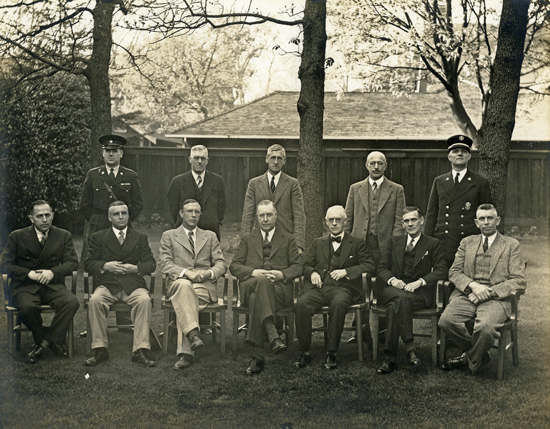
    [Photo: Oak Bay Archives Accn 2017-049-090, Reeve R.R. Taylor, centre, ca. 1940 with municipal council and staff.]

    George Murdoch (Reeve 1959-1963) notes in his unpublished History of Oak Bay for 1968 that "the Minister of Municipalities advised in April that, through a change in the Municipal Act, reeves and councillors of district municipalities were henceforth to have the respective titles of mayor and aldermen ". The change in terminology from Reeve to Mayor occurs between one Council meeting and the next in April 1968, during the tenure of FW Hawes.

    1. 1906 - 1908 William Edgar Oliver (1867-1920)

    2. 1909 - 1911 William E Henderson (1837-1931)

    1. 1912 W E Oliver

    3. 1913 Francis Mawson Rattenbury (1867-1935)

    1. 1914 - 1915 W E Oliver

    4. 1916 - 1917 Marshall P Gordon (1862-1929)

    5. 1918 Newton Townley Burdick (to April 9) (1882-1953)

    6. 1918 - 1919 Charles E Wilson (April 17 1918 – December 1919)

    7. 1920 - 1922 Samuel James Drake (1874-1940)

    8. 1923 -1924 Harold Frederick Hewlett (1887-1961) [source: death cert, BC Archives]

    9. 1925 - 1927 Herbert Anscomb (1892-1972)

    10. 1928 - 1932 Ernest C Hayward (d.1933)

    11. 1933 - 1935 Robert W Mayhew, later MP (1880-1971)

    12. 1936 - 1940 Richard Ratcliffe Taylor (1884-1942)

    13. 1941 - 1945 Walter Leonard (Len) Woodhouse (1895-1967)

    14. 1946 - 1947 Walter Mitchell Walker (1887-1983)

    15. 1948 - 1949 Robert Alexander Burnie Wootton (1901-1982)

    16. 1950 - 1953 Philip Archibald Gibbs, later MLA (1893-1960)

    17. 1954 - 1956 Frederick Elford Norris (1910-2003)

    18. 1959 - 1963 George Murdoch (1893-1979)

    19. 1964 - 1967 Allan Leslie Cox (b.1927)

    20. 1968 - 1969 Frederick William Hawes

    21. 1970 - 1973 Frances Henrietta Elford (1914-2002)

    22. 1974 - 1979 Brian Smith (b.1934)

    23. 1980 – 1983 J Douglas Watts

    24. 1986 - 1990 Susan Brice

    25. 1991 – 1996 Diana Butler

    26. 1997 – 2011 Christopher M Causton

    27. 2011 - 2018 Nils Jensen (d.2019)

    28. 2018 - Kevin Murdoch

    Sources: Minutes of Oak Bay Council, passim; 'Fifty Years of Growth: 1906-1956 Golden Jubilee Souvenir Booklet"; portraits series in Oak Bay Municipal Hall; British Columbia City Directories.

    Questions? Comments? Please contact the Archivist

Page last updated: 07 May 2024, 05:24 PM